This sheet supports the simplified Who Pays preview. Exact amounts remain in the linked schedules; the main page rounds millions and percentages to one decimal.
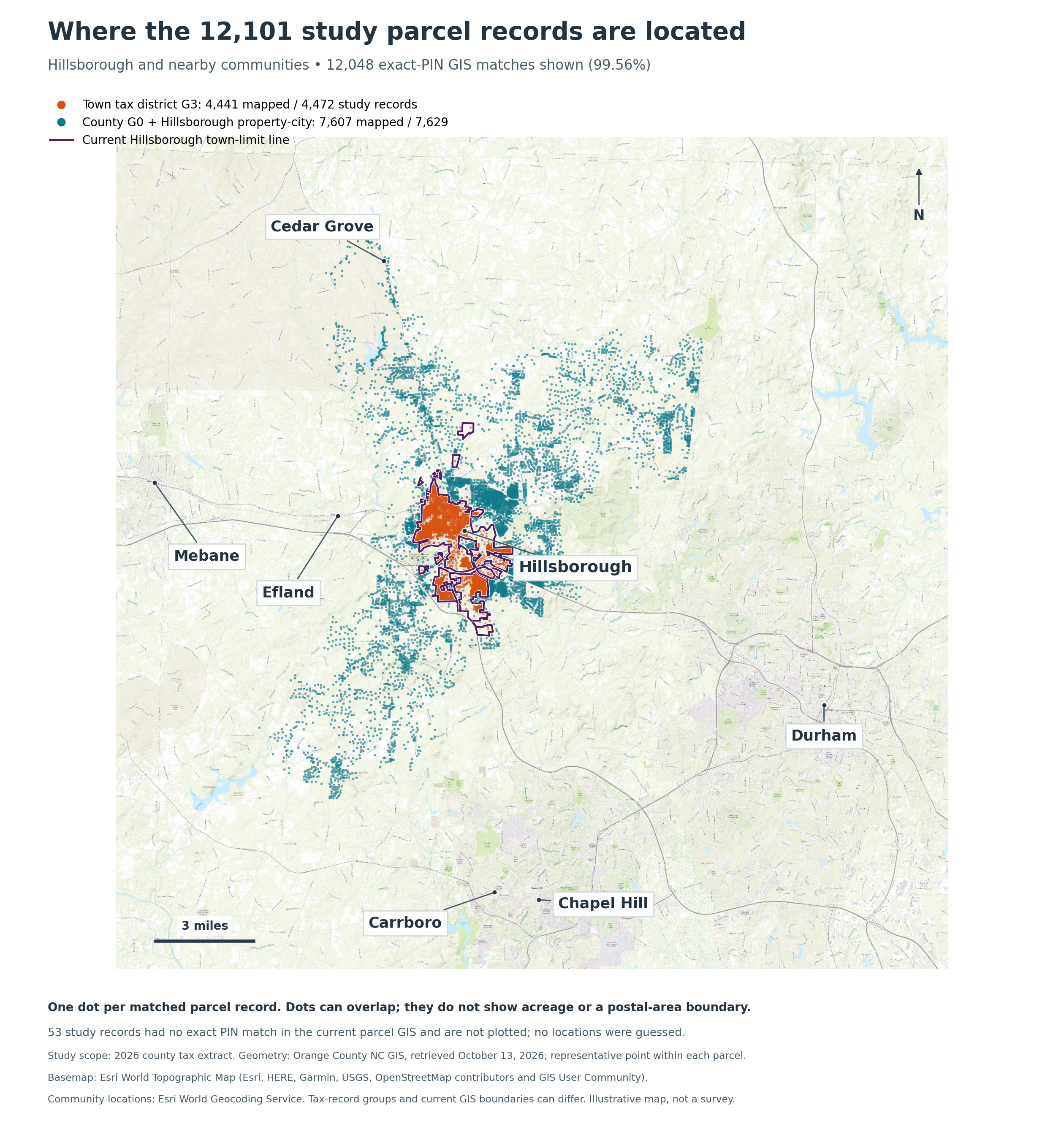
The maps share three colors: blue-gray for Town property tax billed (including partial relief), dark teal for verified full exemption, and gold for unresolved, mixed or other footprints. Gray outside the municipal line is outside Town, not a Town exemption. On the downtown map, the lighter background outside the study is unclassified context. The regional overview retains its original jurisdiction colors and is clearly labeled as geographic rather than exemption mapping.
The frozen August 4 records reconcile to 4,472 complete assessment IDs: 4,124 with a positive PAID/UNPAID Town levy; 183 verified fully exempt; and 165 other (160 released-only and five centrally assessed utilities). The earlier 188 no-positive-levy group includes five utilities and must not be described as 188 verified full exemptions. Full exemption requires an explicit assessment exemption covering the positive gross assessment, no positive active Town levy, and no conflicting taxable active bill. Released bills do not establish exemption. Billed does not mean collected.
All full assessment IDs, including condo and lease suffixes, remain intact. Billing rows are grouped by complete ID; any positive active Town bill places that record in the billed category. Records are counted once, never once per building row or polygon overlap. Exact GIS matches cover 4,441 IDs: 4,109 billed, 182 exempt and 150 other. The 31 unmatched IDs comprise 15 billed, one exempt and 15 other. A prior countywide exact-PIN query found no matches; no successor footprints are invented.
Eight existing base identifiers associated with missing suffix accounts are conservatively shown as other, without assigning those absent accounts a geometry. GIS footprints with different category assignments overlap in 77 pairs. Their intersecting land (union, not summed pairs) is shown gold; this includes parent/condo and other coincident geometry conflicts. Same-category overlaps retain that category. These are mapping ambiguities, not new legal tax classifications or an allocation of condo ownership shares. Features with no exact Town assessment record are also other inside the boundary. Differences between historical assessment IDs and current GIS features must not be interpreted as new parcel totals.
The complete October 19 municipal geometry is unchanged from v6: 19 features, 18 nonempty, 21 union parts including small slivers. The full municipal extent plus 600 feet contains 7,913 distinct GIS PINs and 1,437 road features. All query batches were checked for completeness. 4,485 GIS features intersect Town by more than one square foot. Before the mixed-area overlay, these are 4,101 billed, 182 exempt and 202 other. These feature counts differ from assessment-record counts and do not measure unique land area. Outside portions of crossing polygons remain gray. Very small crossings may reflect GIS alignment.
Saved-source checks confirm USPS (9874161145), County courthouse (9874058688), old courthouse (9874066106), Town cemetery (9874190573), Town campus (9874088727) and UNC hospital (9873320287) are verified exempt and have no mixed overlay. The planned train-station site and planned fire headquarters remain described as planned; completion is not inferred. South Churton and numbered landmark anchors are retained. The approved downtown study, Town Center future-land-use outline, municipal boundary and official historic district are distinct geographies; the downtown study is not the official historic district.
Assessment/bills: August 4, 2026. New municipal GIS: October 19. Downtown geometry: October 18 saved study; prior regional image: October 13. No tax aggregates or approved study boundary were changed. Official source layers: gis.orangecountync.gov/arcgis/rest/services/WebZoningService/MapServer/14 (municipal), /3 (roads), and WebParcelService/MapServer/0 (parcels), EPSG:2264.
“No Town tax shown” describes the saved local records, not a finding that every property is legally fully exempt or owes no tax of any kind. Partial reductions may apply to records that still have Town tax billed. “Property tax records” preserves complete assessment IDs, including suffixes; it does not imply a one-to-one count of distinct parcel footprints. The approved downtown study boundary is different from both the municipal boundary and the official Historic District. Completion of the planned fire headquarters has not been verified.
| Measure | Definition / limitation |
|---|---|
| Town: 4,472 | Unique complete assessment ParcelID values, including suffixes, with JURISDICTION=HILLSBOROUGH and District=G3. This is a tax-record cohort, not a certified GIS municipal inventory. |
| Surrounding address group: 7,629 | JURISDICTION=COUNTY and normalized situs City=HILLSBOROUGH. This is not owner mailing city, an official ZIP polygon, the ETJ, or the Historic District. |
| Combined: 12,101 | Nonoverlapping union. Appraisal $6,587,714,782: Town $2,656,395,206 (40.3%); County/address $3,931,319,576 (59.7%). The situs-city-only group has 11,839 records; 262 additional Town records have blank City. |
| Expanded downtown: 805 PINs | Approved October 18 parcel list, retaining all 86 original Town Center PINs. Known appraisal $457,126,804 across 802 matches. All selected footprints are at least 99% inside Town in the saved overlay. The 637-PIN Historic District study remains separate. |
4,124 positive-levy records + 93 zero-levy active bills + 95 explicit fully exempt assessment-only records + 160 released-only records = 4,472. The 188 records without a positive local levy carry $460.8M appraisal, or 17.4% of Town-cohort appraisal. Five are utility records with unresolved central taxation; do not describe the whole group as legally fully exempt. The older overview used the broader fully exempt label; this preview makes that limitation explicit. Active Town levy is $11,062,030; released-only nominal appraisal totals $559. No current payment or delinquency conclusion is drawn. Personal/business property, vehicles, central utilities and split jurisdictions require tax-abstract reconciliation.
| Category | PINs | Appraisal |
|---|---|---|
| Fully taxable | 703 | $334,462,300 |
| Partially reduced - exemption/exclusion | 27 | $9,620,900 |
| Partially reduced - deferral | 0 | $0 |
| Fully exempt | 65 | $111,605,100 |
| Utility - central assessment unresolved | 2 | $1,438,100 |
| Released bills / other | 5 | $404 |
| Unresolved | 3 | Unknown |
Government/public: 43 fully exempt PINs, $92,775,800. All fully exempt: 65 PINs, $111,605,100. Government is included in that total. Of those 65, 44 have matched bills and 21 have explicit full-value assessment exemptions only. The two utility PINs are not counted as fully exempt because centrally assessed taxes remain unresolved. Three unmatched King Street PINs—9874064203, 9874064233 and 9874064264—have unknown values and levies. Five released bills contain $404 nominal appraisal. Known non-released downtown Town levy: $1,747,350.41.
No confirmed HIS-coded recipient or recorded deferral appears within the approved 805-PIN list. This does not prove that every form of historic-property relief is absent: the 27 partial exclusions have blank codes. Nine exact 50% reductions cannot establish a historic program by themselves. Three known HIS records—Eno Cotton Mill units 1 and 10, and Bellevue Mill—are outside this study. Historic Hillsborough Commission at 319 N. Churton is fully exempt, not a demonstrated 50% historic deferral.
V5 replaces remote landmark text and faint leaders with numbered markers, each anchored inside its verified parcel and identified in the map key. The dark eastern parcel in an earlier review image is Orange County Board of Education property, 200 E. King Street, PIN 9874262348—not Montrose Gardens. Old courthouse is the separate parcel at 104 E. King Street, PIN 9874066106. Its former label sat over the education parcel even though its leader targeted the courthouse; that presentation was misleading. Montrose Gardens is PIN 9874363680, farther east and outside this study area. These identifications use the saved parcel and assessment records; no new investigation or boundary changes were made. Numbered landmark anchor audit — retained in the local research package; not included in this website candidate.
The downtown map retained from v3 anchors every displayed street name directly on the named saved County road centerline, with rotation calculated from its local direction. Roads, parcels, municipal boundaries and Town Center use EPSG:2264 (North Carolina State Plane, US survey feet); no reprojection was needed. V2 used manually entered text coordinates; those have been removed. V5 recenters the view to show all approved parcels and the separate Montrose marker; its equal aspect ratio and parcel boundaries remain unchanged. The regional map is an unchanged saved image; its labels have not been repositioned or recolored. Churton, King, Corbin, Cornelius, Cameron, Nash, Wake, Margaret, Tryon and St. Marys were checked. Street anchor audit — retained in the local research package; not included in this website candidate.
Town Ledger’s expanded downtown study area is the approved 805-record boundary. Town-designated Town Center is the official future-land-use area; neither label means the municipal boundary or Historic District.
County original detailed assessment and FullRealBills workbooks, dated August 4, 2026, retained under Property Tax Research/01_County_Originals/tax-2026/export-2026-08-04. Town classification: saved analysis-v3 reconciliation and Hillsborough_Tax_Base_Overview_2026-10-15.pdf. Downtown: approved proposal and audited Expanded Downtown Who Pays Analysis 2026-10-18. GIS: saved County municipal, parcel and street layers and Town land-use layer retrieved October 18. Fire headquarters: adopted FY26–28 Town budget, printed p. 140, identifies planned 604 N. Churton site; parcel match verified, building completion unverified.
Assessment values are counted once per complete ID, never summed across repeated building rows. Map 1 now reuses the unchanged saved regional PNG, Hillsborough-study-parcels-regional-map.png. Its own legend reports 12,048 exact-ID matches (99.56%): 4,441 of 4,472 Town records and 7,607 of 7,629 County/Hillsborough-address records. Thus 31 Town and 22 County/address records are unplotted. These coverage counts are reported from the saved map, not independently reconstructed; its underlying broad geometry and match schedule were not located. One representative dot is shown per matched record; dots overlap and are not counts of distinct polygon footprints or acreage. Orange and teal represent the saved tax-record groups, not a new inside/outside spatial reclassification. The map warns that tax-record groups and current municipal geometry can differ. No greater-Hillsborough polygon is drawn. GIS date: October 13, 2026; tax snapshot: August 4, 2026. The original basemap and source attribution remain in the image. Open the unchanged source map. The regional map replaces the limited municipal-locator close-up from v3. Map 3 retains the separate downtown close-up and highlights the approved list without reopening its geography. Map outlines are GIS representations, not surveys. Full-precision source schedules govern rounded display figures.